The Desolation Canyon Project
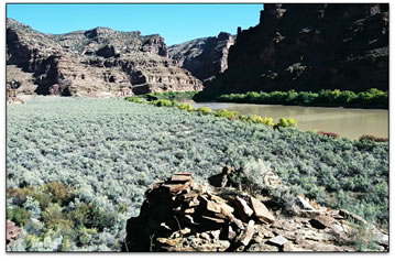
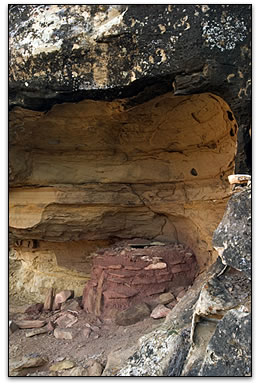
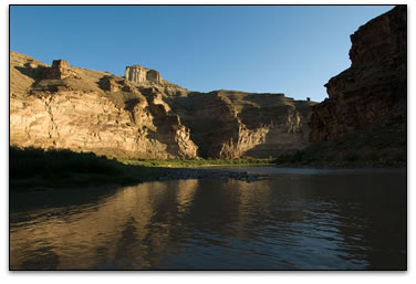
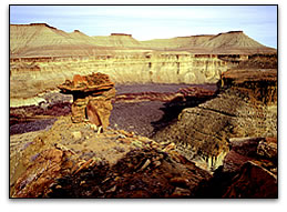
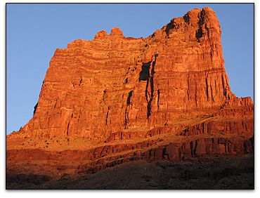
Famous the world over for its stunning whitewater and wilderness experiences, Desolation Canyon in eastern Utah is also a largely undiscovered archaeological treasure worthy of its designation as a National Historic Landmark. For thousands of years, humans have moved up and down the Green River through impenetrable cliffs and Gothic spires, pursuing bighorn sheep, elk and deer, and gathering together a rich harvest of seeds and berries growing along the tributary creeks. A thousand years ago, some of them – archaeologists call them the Fremont people – even stayed long enough to plant and cultivate maize along the river banks, building stone-and-adobe granaries in the cliffs and becoming the first to put down roots in this forbidding landscape. They did not stay long, maybe a generation or two. Today, only the abandoned relics and ruins of long-vanished people greet the thousands of visitors who float the nearly 90 miles from Sand Wash to Green River every year.
Archaeologists know very little about the people who lived in Desolation Canyon, how they adapted to this remarkable wilderness or what eventually happened to them. Because of its rugged isolation, it has been extremely difficult and expensive for scientists to get into Desolation Canyon to study the remains of past cultures. Beginning in 1931, archaeologists had from time to time ventured into the canyon, but rarely did they write detailed accounts of what they saw. And not until CPAA’s first expedition in 2006 did archaeologists from throughout the region come together to study the canyon in a comprehensive manner. Today, about 75 sites have been documented along the canyon corridor, and for the first time federal managers have the information they need to proactively manage these sites for their long-term protection.
Project Objectives
The spectacular archaeological sites of Desolation Canyon collectively constitute an important and largely unspoiled cultural heritage of national significance. Over the past four decades, many of these sites have been discovered and routinely damaged, sometimes maliciously and sometimes inadvertently, by visitors who float Desolation Canyon every year. A large number of sites are in pristine condition and have yet to be discovered by canyon visitors. The vast majority of all sites in the canyon have never been formally documented, and no database currently exists whereby adverse effects can be determined and measured, and through which strategies can be implemented to deter future damage to these sites. Furthermore, there is an absence of basic data as to site location, site condition and the relative frequency and nature of site visitation. This greatly limits efforts to monitor and protect these resources for future generations.
The Desolation Canyon Project is designed to address the urgent need for baseline data by thoroughly documenting cultural resources in areas of the canyon receiving the heaviest visitor impacts and to assess the effects of those impacts on site integrity. This will provide managers with information needed to monitor sites for ongoing degradation and thereby implement strategies to minimize the impacts of site visitation. This effort will also assist in the training of river rangers in site documentation, which will augment the database into the future. This effort also includes public outreach initiatives about the fragile nature of cultural resources, the need to preserve and protect them and the proper behavior expected of visitors to such sites.
This project has two broad objectives: (1) Document the nature of archaeological sites along the Green River to better understand the spatial and temporal nature of prehistoric human adaptations in this region, and (2) to determine what kind of condition the sites are in after decades of commercial river running. The intent of both objectives is to increase our understanding of the archaeological record of this unknown region, thereby providing federal land managers – the Bureau of Land Management – with data it needs to better manage and protect these sites.
Project Partners
The Desolation Canyon Project is a multi-year research project initiated by the Colorado Plateau Archaeological Alliance (CPAA), in collaboration with and financial support from the Utah Division of State History, the Bureau of Land Management, the Utah Museum of Natural History and the National Park Service. The project is organized and implemented by CPAA director/archaeologist Jerry D. Spangler, who generates all written reports and manages all field data. The Utah Division of State History through Utah State Archaeologist Kevin T. Jones provides technical staff to assist with data collection and site assessments, and the University of Utah and Utah Museum of Natural History provide archaeology students who assist in the data collection and who in turn receive training in preservation archaeology. The Bureau of Land Management (Price Field Office) assists the project by providing equipment support, primarily river gear and transportation support, but also personnel who assist field crews and who will in turn receive training on archaeological preservation. Many private companies and individuals have also contributed generously to the project, either in cash, discounts or supplies. Among the most generous contributors: The National Park Service, Bureau of Land Management, Holland & Hart, Rimini Coffee, Abajo Archaeology, Barber Consulting, Katadyn and Aire. Collectively, more than $100,000 in financial support, personnel and in-kind gear and supplies have been contributed to the project.
Long-Term Needs
The Desolation Canyon Project actively seeks corporate financial contributions, individual donations and government grants in the amount of $100,000 annually through 2013 to complete its ground-breaking research along the Green River, and to expand the research to other areas of the Green River also impacted by recreation and development. In the years ahead, CPAA will extend its research into:
- Labyrinth Canyon
- Upper Desolation Canyon
- Flaming Gorge
- Dinosaur National Monument
Project History
The first phase of the study was conducted in September 2006 and consisted of surveys near Rock House Canyon, Flat Canyon and Steer Ridge Canyon. This research, conducted in partnership with the Utah Division of State History, identified a spatial pattern consisting of masonry storage structures and rock art sites located near the confluences of these side drainages, but without convincing evidence of nearby residential occupations. The distribution of these sites could imply that prehistoric farmers occupied the Green River corridor only seasonally, perhaps during spring planting and fall harvests, and that they were never there in significant numbers or for any significant length of time. Two radiocarbon dates suggested this occupation occurred at about A.D. 1000 to 1050. There was minimal evidence of vandalism or graffiti or other impacts from river recreation.
CPAA revisited Desolation Canyon in May 2007 in partnership with the Bureau of Land Management (BLM), Utah Division of State History and the Utah Museum of Natural History. The project had two additional, more specific goals: (1) Investigate Jack Canyon, a western tributary of the Green River with a reliable water source, to determine if the spatial pattern of archaeological sites was similar to that observed in Flat Canyon, also a western tributary with consistent water much of the year. (2) Document sites the BLM knows receive significant public visitation, or were at risk of future visitation, to establish a baseline through which future management decisions could better protect those sites. These investigations revealed no archaeological sites around the mouth of the canyon, but they found increasing density of sites beginning in the middle portion of Jack Canyon. Unlike the 2006 findings, crews observed a prevalence of graffiti and vandalism, including looters’ screens that had been left behind.
In July 2007, CPAA, at the request of BLM river managers, examined sites around the Sand Wash boat launch to determine the nature of adverse impacts resulting from camping, and to document known but undocumented historic sites in the area. During a three-day period, 10 historic and two prehistoric archaeological sites were documented. All identified sites were known to the BLM or were discovered during the course of documenting known sites.
With the assistance of Challenge Cost Share Program funding from the National Park Service, CPAA returned to Desolation Canyon in October 2007 in partnership with the Utah Division of State History, the Utah Museum of Natural History, the Bureau of Land Management and the National Park Service. The seven-day river reconnaissance involved investigations of Peters Point, Cedar Ridge Canyon, Rock Creek, Calf Creek and Price River, all on the west side of the Green River. Archaeologists found that many sites have been impacted to some degree by graffiti, illegal excavations and vandalism, but that most of observable damage to cultural sites was minor. These impacts appear to have occurred intermittently from 1894 through at least 2000.
Desolation Canyon NHL
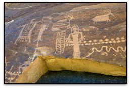
Desolation Canyon National Historic Landmark (DCNHL) was created on Nov. 24, 1968, to commemorate the historic achievements of Maj. John Wesley Powell, an intrepid one-armed explorer of the Green and Colorado Rivers who later became a preeminent scientist and anthropologist of the 19th century. The NHL was so designated to “protect unique historic values” associated with Powell’s 1869 and 1871 expeditions, in particular the environment of Desolation Canyon that remains virtually undeveloped and unchanged in appearance from that observed more than a century ago. Archaeological resources within the NHL were certainly recognized and mentioned in the journals of the various participants of the two Powell expeditions through the NHL. And today, NHL land managers recognize that the public’s opportunity to view cultural sites along the canyon corridor is an integral component of the historic values of the NHL, reflecting Powell’s lifelong interest in aboriginal peoples and archaeological resources of the West. This interest ultimately led Powell to establish the Smithsonian Institution’s Bureau of Ethnology, which he headed from 1879 until his death. Unknown at the time of the NHL designation was that Desolation Canyon is home to hundreds upon hundreds of spectacular rock art sites, masonry granaries, towers and stone buildings more than 1,000 years old, most of them remnants of long-vanished Fremont culture of which archaeologists know very little in this area.
The Colorado Plateau Archaeological Alliance is a non-profit organization created under the laws of the state of Utah
(Internal Revenue Service 501(c)(3) charitable organization).