The Greater Cedar Mesa Project
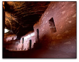
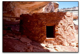
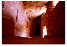
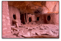
The Cedar Mesa area in southeastern Utah has emerged over the past three decades as an international destination for backpackers, ATV enthusiasts, river runners and weekend day-hikers – all lured to by the thousands of remarkably well preserved ancient cliff-dwellings of those who lived in these slickrock canyons from about A.D. 1 to 1300. As the region’s reputation for backcountry recreation has increased, so too have the damage and destruction – both intentional and inadvertent – from the tens of thousands who visit Cedar Mesa every year. In effect, the area is now one of the most famous archaeological districts in America but one that is increasingly at risk of being trampled to death.
As the ancient pueblos rapidly deteriorate, the Bureau of Land Management, which has management responsibility for the greater Cedar Mesa, struggles to manage a region where there is little or no data as to how many ancient sites there are on the mesa, where those sites are located, and whether or not they are being damaged or destroyed by the crush of visitors now venturing into the backcountry. Less than 5 percent of the greater Cedar Mesa has been surveyed for cultural resources, and some of the most famous ruins that draw thousands of visitors annually have never been formally documented. The BLM budget for management of cultural resources there have remained largely static, preventing any proactive or creative management of cultural resources or identification of areas most at risk to damage and degradation. BLM has typically responded after sites are damaged or destroyed, rather than implementing proactive measures to prevent the damage from occurring. The sheer number of sites and visitors makes resource management a daunting challenge.
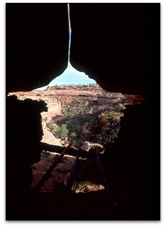
Back country recreational use of the greater Cedar Mesa area has increased exponentially since the 1970s, mostly from backcountry day-hikers and backpackers. Since the 1990s, there has also been an explosion in ATV use that has resulted in webs of new trails and routes leading to remote canyons and ancient ruins that were once protected by their formidable isolation. Canyons with spectacular ruins rarely seen before are now easily accessible to hundreds if not thousands of people every year. And many are now appearing in guidebooks complete with GPS coordinates. Not surprisingly, the increased publicity has resulted in increases in vandalism and looting, as well as inadvertent destruction by visitors unaware of proper behavior on and around these ancient sites that have weathered centuries.
The Partners
The Greater Cedar Mesa Project (GCM Project) is a collaborative partnership involving government, conservation interests and the private sector. The lead partners are the Colorado Plateau Archaeological Alliance (CPAA), a Utah-based 501c3 corporation that advocates for the protection of archaeological sites on public lands, and the National Trust for Historic Preservation (NTHP), the nation’s preeminent historic preservation advocacy group based out of Washington D.C. Both CPAA and NTHP have committed a minimum of $70,000 to begin the initial phase of the project (2008). The project is anticipated to last through 2012.
The Bureau of Land Management and the Utah Division of State History are currently collaborating partners, assisting with access to relevant archaeological and environmental data, GIS services, donated office space and on-the-ground logistics. Federal financial assistance is anticipated in 2009 contingent upon a 50 percent match from non-federal sources. With an annual budget of $250,000, CPAA and NTHP are currently seeking annual commitments from corporate and governmental entities, as well as private individuals.
Goals and Objectives
The ultimate objective of the GCM Project is to establish a reference from which nationally renowned archaeological sites can be proactively and aggressively managed as a cultural legacy for residents of southeastern Utah, as well as future generations of all Americans. Quite simply, the BLM cannot manage these resources if it does not even know what resources are there or the condition of these sites after generations of looting and neglect. To this end, the project is designed to include (1) a scientific baseline from which proactive federal land management decisions can then be implemented. This will include examination of those areas being highly impacted by high levels of visitation (e.g., Bullet Canyon, Grand Gulch, McLloyd Canyon, San Juan River) and high site degradation, and sample surveys of those areas where little is currently known. (2) The identification of those areas being directly or indirectly impacted by enhanced vehicular access. This would include the identification of areas where vehicle travel is appropriate and where it is not. (3) Re-establishing and reinvigorating the Friends of Cedar Mesa organization and assisting them in the promulgation of backcountry ethics that includes proper behavior on and around archaeological sites, leave no trace camping, minimal-impact ATV use and providing volunteer assistance and visitor contact for BLM rangers.
The Colorado Plateau Archaeological Alliance is a non-profit organization created under the laws of the state of Utah
(Internal Revenue Service 501(c)(3) charitable organization).